
Mount Kinabalu Summit 3D/2N
Mount Kinabalu & Kiulu White Water Rafting 3D/2N
Mount Kinabalu Summit & Poring Hot Spring 3D/2N
Untuk tempahan sila berhubung dengan admin SOS dan sediakan beberapa dokumen seperti berikut :
1- Senarai Nama Peserta Lengkap
2- Jadual berlepas (sekiranya sudah membeli tiket penerbangan)
3- Deposit 50% bagi setiap seorang
*Perlu di ingatkan tempahan bagi pendakian Gunung Kinabalu adalah 6 bulan awal!

MAKLUMAT GUNUNG KINABALU
Gunung tertinggi di Malaysia ini menjadi kebanggaan rakyat Sabah khususnya. Gunung ini diwartakan Taman Negara dan juga diiktiraf sebagai Warisan Dunia (World Heritage) mempunyai keunikan tersendiri.
Pendaki dikehendaki mendaftar dan mendapat permit mendaki di HQ Kinabalu Park. Waktu mula mendaki dibuka jam 8:30pagi - 12:30tgh. Kebiasaannya pendaki akan mendaki melalui Timpohon Gate. Pendaki juga boleh membuat pilihan melalui Mersilau trail, di Kundasang. Bagaimanapun sejarah pendakian Gunting Lagadan dan Sir Hugh Low bukanlah melalui kedua-dua trail ini. Setiap Checkpoint dibina pondok untuk berehat serta ada kemudahan tandas dan air.
Timpohon Gate
Pintu masuk ini hanya 4KM dari HQ Kinabalu Park. Pendaki boleh berkenderaan sendiri atau menggunakan kenderaan Kinabalu Park dengan sedikit kos dikenakan. Sebuah pondok dan pelantar dibina di pintu masuk ini.
Carson Waterfall
5 minit berjalan dari Timpohon Gate pendaki akan melintas air terjun ini. Air terjun ini tidak begitu gah tapi tetap mendamaikan hati.
Pondok Kandis/ Kandis Shelter
Hampir 1KM dari Timpohon Gate. Laluan adakalanya mendatar, adakalanya mendaki. Lereng-lereng bukit telah ditarah menjadi tangga dan disokong dengan papan.
Pondok Ubah/ Ubah Shelter
Didirikan 1.5KM dari Timpohon Gate.
Pondok Lowi
Jarak 2KM dari Timpohon Gate.
Pondok Mempening
Trail ke sini dari pondok sebelumnya penuh berbatu.
RTM Stesen - Helipad
Pendaki hanya akan lalu berdekatan RTM Stesen, bunyi generator stesen ini jelas kedengaran dari trail pendaki. Pendaki boleh melencong sebentar ke Helipad dan dapat melihat puncak kinabalu dengan jelas sekirannya cuaca baik dan tidak berawan.
Layang-layang / Layang-layang Hut
Disini didirikan pondok dan juga asrama untuk pekerja Kinabalu Park. Berada di ketinggian 2702.3m d.p.l dan hampir 4KM dari Timpohon Gate.
Simpang Mersilau
Ada papan tanda arah Mersilau. Kini sedang didirikan satu bangunan dipersimpangan trail ini dijangka siap menjelang tahun 2006.
Pondok Villosa
Menghampiri pondok ini, pokok-pokok bonsai banyak dan semakin rendah disekitar trail. Kawasan pondok ini berada dipuncak bukit dan terdedah dengan angin.
Pondok Paka
Pondok ini agak tersembunyi dibalik pokok-pokok yang tinggi menjanjikan satu suasana redup buat pendaki. Trail ke sini cukup menarik, tangga-tangga berbatu dan pokok-pokok bonsai menghiasi laluan pendaki disamping puncak Kinabalu tersergam diatas. Terdapat Gua Paka berdekatan pondok ini yang dikatakan menjadi tempat perteduhan pendaki terdahulu.
Hut (Waras, Panar Laban, Laban Rata, Gunting Lagadan, Burlington)
Hut-hut diatas adalah antara asrama untuk pendaki bermalam. Setiap satu hut terletak berdekatan walaupun di ketinggian berbeza. Paling rendah Waras Hut (3243.7m), Burlington Hut (3270.9m), Laban Rata (3272.7m), Panar Laban (3314.3m) dan paling tinggi Gunting Lagadan Hut (3323.5m). Beberapa kemudahan asas telah disediakan seperti katil, gebah/sleeping beg, bantal, dapur memasak, periuk-miuk, pinggan mangkuk, tandas dan bilik mandi. Satu Restoren ada ditempatkan di Laban Rata.
Sayat-Sayat Hut
Disini diletakkan petugas merekodkan pendaki yang mendaki ke Puncak Kinabalu dan pendaki kena melaporkan kembali apabila turun dari puncak. Bagi pendaki yang tidak mampu meneruskan pendakian boleh berehat di sini sebelum berpatah balik. Kejayaan pendaki menjejak ke puncak tertinggi juga dilaporkan disini oleh jurupandu arah masing-masing.
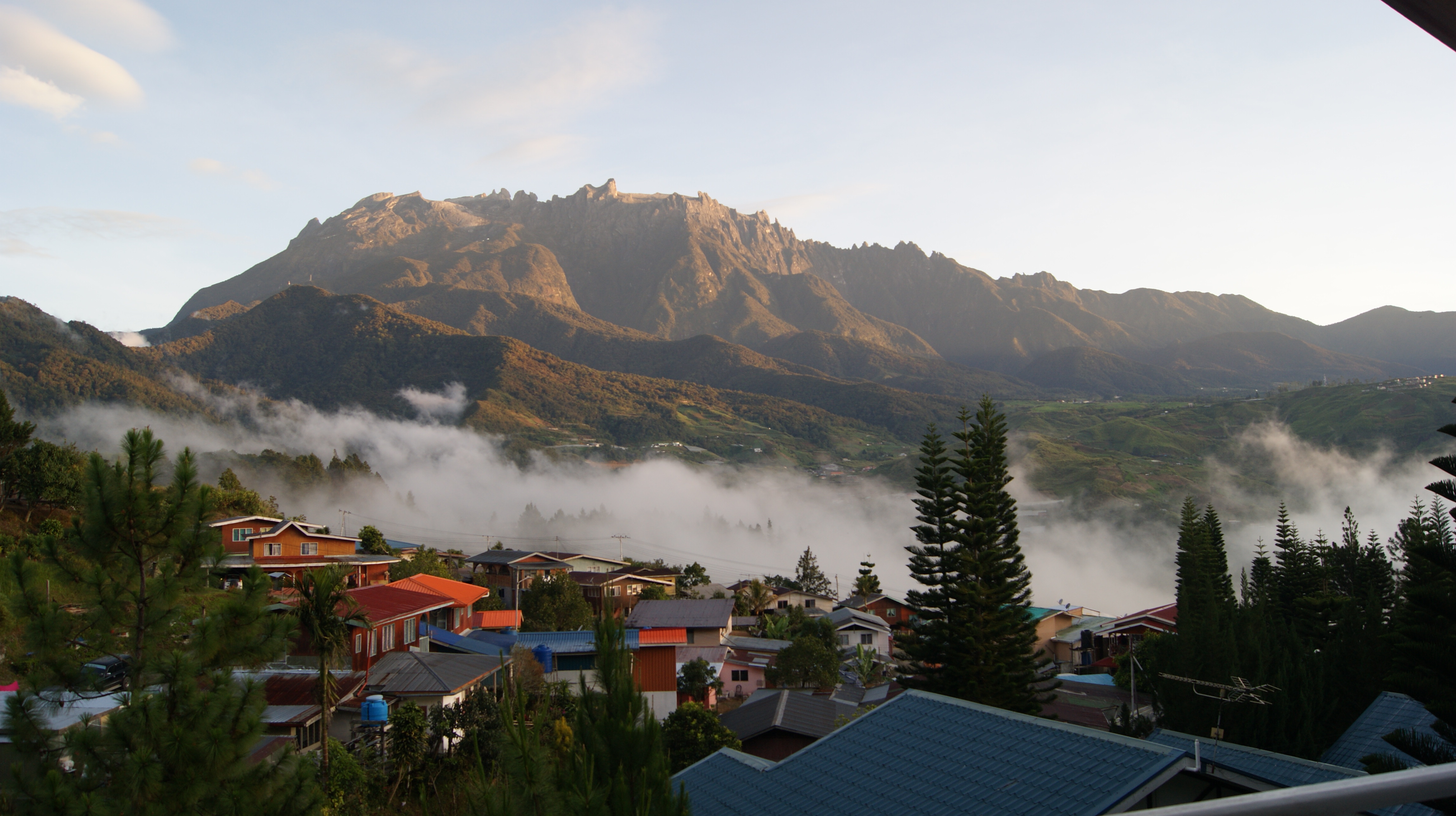
Puncak-puncak Kinabalu
Gunung Kinabalu berdiri megah dengan beberapa puncak. Puncak tertinggi, Low's Peak (4095m) diambil sempena nama Hugh Low. Puncak-puncak lain antaranya, Alexandra Peak (4003m), St. John's Peak (4092m), Victoria Peak (4088m), Ugly Sister Peak (4032m), Donkey Ears (4054m) yang umpama telinga keldai dan South Peak (3933m) dengan keadaan struktur batu yang unik.
Mersilau Trail
Trail ini hanya lebih 1.5KM dari Timpohon Trail. Trail ini lebih mencabar kerana pendaki kena mendaki dan menuruni cerun samaada pendaki mendaki ke Puncak mahupun sebaliknya. Sebahagian trail ini menyusuri permatang dan berlatarkan air terjun.
Jambatan Gantung (Kipuyut)
Ini antara checkpoint yang menarik di Mersilau Trail selain dari beberapa pondok antaranya Pondok Lompoyou. Jambatan sejauh kira-kira 40m ini terletak ditengah-tengah hutan merintangi jeram berbatu.
Mersilau Nature Resort
Disinilah permulaan/tamat trail Mersilau. Pejabat tempat pendaki yang melalui trail ini melaporkan diri. Hampir sama seperti HQ Kinabalu Park, Kemudahan asas seperti surau, kafeteria, bilik mandi, telefon awam turut disediakan disini. Pengunjung juga boleh melawat mini Muzium Kinabalu yang disini. Sukarnya disini, Mersilau Nature Resort jauh dari jalan utama Kinabalu-Ranau dan pekan Kundasang.
Hugh Low Trail
Trail ini juga dikenali Jejak Lagadan merupakan trail yang digunakan Hugh Low dan Gunting Lagadan semasa mula-mula menawan puncak Kinabalu. Trail ini bermula dari ketinggian 902m d.p.l. dan berkecerunan 60 darjah dan banyak melalui cerun-cerun berbatu licin serta berjuram yang dalam. Trail ini akan bertemu dengan trail Timpohon di Pondok Paka
Kg. Kiau Nuluh
Trail ini bermula dari Kg. Kiau Nuluh berdekatan sempadan Taman Kinabalu. Banyak pacat di lantai hutan ini. Pendaki boleh bermalam di Kem site pertama setelah melintasi sempadan Taman Negara. Pendaki perlu membawa khemah sendiri kerana tiada kemudahan asrama/pondok disediakan dan tiada sumber air di kem site ini. Suhu malam boleh mencecah 15darjah celcius.
Tiong-Tiong
Berada di sebelah barat gunung Kinabalu dan laluan kesini penuh dengan pokok resam kipas. Pendaki boleh bermalam di checkpoint ini. suhu malam boleh mencecah 5 darjah celsius. Tiong-tiong sebenarnya tidak begitu jauh dari stesen Komborongoh (KM2 Timpohon trail). Antara perkara menarik, pendaki boleh melihat puncak G. Kinabalu dari sudut yang berlainan sekali dan jarang dirakamkan oleh media. Terdapat sebuah kolam kecil yang dikatakan tidak pernah kering walaupun musim kemarau. Kedinginan air kolam ini menjadi sumber air pendaki. Pemandangan matahari terbenam disini juga menarik sekali.
Snow Field
Tempat ini dinamakan sempena nama lumut dari jenis Snow Fern yang banyak terdapat disekitarnya. Lumut yang bewarna putih ini seolah-olah salji yang menutupi permukaan batu.
Gua Paka
Pendakian ke sini dikategorikan laluan berbahaya dan perlu lebih berhati-hati. Laluan merentasi tebing batu yang licin dan bertumbuhan aneh. Pendaki boleh bermalam dan berteduh di gua ini. Terdapat sungai berdekatan gua dan paras air sungai berubah mengikut keadaan hujan.
ehsan dari : OGKL.COM
SABAH: The Culture & People
The History
Sabah is one of 13 member states of Malaysia. It is located on the northern portion of the island of Borneo. It is the second largest state in the country after Sarawak, which it borders on its south-west. It also shares a border with the province of East Kalimantan of Indonesia in the south. In spite of its status as a Malaysian state, Sabah remains a disputed territory; the Philippines has a dormant claim over much of the eastern part of the territory. The capital of Sabah is Kota Kinabalu, formerly known as Jesselton. Sabah is known as "Sabah, negeri di bawah bayu", which means "Sabah, the land below the wind", because of its location just south of the typhoon-prone region around the Philippines.
The region of present-day Sabah was discovered by Europeans around the early 16th century. This was during the period when the Sultanate was in its 'golden era'. The region was known as Sava to Portuguese explorers. In 1658 the Sultan of Brunei ceded the northeast portion of Borneo to the Sultan of Sulu in compensation for the latter's help in settling a civil war in the Brunei Sultanate. In 1761 an officer of the British East India Company, Alexander Dalrymple, concluded an agreement with the Sultan of Sulu to allow him to set up a trading post in the region. This, together with other attempts to build a settlement and a military station centering around Pulau Balambangan, proved to be a failure. There was minimal foreign interest in this region afterward and control over most parts of north Borneo seems to have remained under the Sultanate of Brunei. The southern portion of Palawan was once part of Sabah, due to Palawan's proximity to Borneo. Southern portions of the island were under the control of the Sultanate of Borneo for more than two centuries, and Islam was introduced. During the same period, trade relations flourished, and intermarriages among the natives and Chinese, Japanese, Arab, and Hindu peoples became commonplace. The intermixing of blood resulted in a distinct breed of Palaweños, both in physical stature and features. In 1749, the Sultanate of Borneo ceded southern Palawan to Spain.[4]
In 1865 the American Consul of Brunei, Claude Lee Moses, obtained a 10-year lease over North Borneo from the Sultan of Brunei. Ownership was then passed to an American trading company owned by J.W. Torrey, T.B. Harris and some Chinese merchants. They set up a base and settlement in Kimanis but this too failed due to financial reasons. The rights of the trading company were then sold to Baron Von Overbeck, the Austrian Consul in Hong Kong, and he later obtained another 10-year renewal of the lease. The rights were subsequently transferred to Alfred Dent, whom in 1881 formed the British North Borneo Provisional Association Ltd.
In the following year, the British North Borneo Company was formed and Kudat was made its capital. In 1883 the capital was moved to Sandakan to capitalise on its potential of vast timber resources. In 1888 North Borneo became a protectorate of the United Kingdom. Administration and control over North Borneo remained in the hands of the Company despite being a protectorate and they effectively ruled until 1942.
Post World War Two, Malaysia joined the Malaya Federation and is now one of the 13 states of Malaysia.
The Geography
The western part of Sabah is generally mountainous, containing the three highest mountains in Malaysia. The most prominent range is the Crocker Range which houses several mountains of varying height from about 1,000 metres to 4,000 metres. At the height of 4,095 metres, Mount Kinabalu is the highest mountain in South East Asia . The jungles of Sabah are classified as rainforests and host a diverse array of plant and animal species. Kinabalu National Park was inscribed as a World Heritage Site in 2000 because of its richness in plant diversity combined with its unique geological, topographical, and climatic conditions.
Lying nearby Mount Kinabalu is Mount Tambuyukon. At a height of 2,579 metres, it is the third highest peak in the country. Adjacent to the Crocker Range is the Trus Madi Range which houses the second highest peak in the country, Mount Trus Madi, at a height of 2,642 metres. There are lower ranges of hills extending towards the western coasts, southern plains, and the interior or central part of Sabah. These mountains and hills are traversed by an extensive network of river valleys and are in most cases covered with dense rainforest.
The central and eastern portion of Sabah are generally lower mountain ranges and plains with occasional hills. Kinabatangan River begins from the western ranges and snakes its way through the central region towards the east coast out into the Sulu Sea. It is the second longest river in Malaysia after Rejang River at a length of 560 kilometres. The forests surrounding the river valley also contains an array of wildlife habitats, and is the largest forest-covered floodplain in Malaysia.
Other important wildlife regions in Sabah include Maliau Basin, Danum Valley, Tabin, Imbak Canyon and Sepilok. These places are either designated as national parks, wildlife reserves, virgin jungle reserves, or protection forest reserve.
Over three quarters of the human population inhabit the coastal plains. Major towns and urban centers have sprouted along the coasts of Sabah. The interior region remains sparsely populated with only villages, and the occasional small towns or townships.
Beyond the coasts of Sabah lie a number of islands and coral reefs, including the largest island in Malaysia, Pulau Banggi. Other large islands include, Pulau Jambongan, Pulau Balambangan, Pulau Timbun Mata, Pulau Bumbun, and Pulau Sebatik. Other popular islands mainly for tourism are, Pulau Sipadan, Pulau Selingan, Pulau Gaya, Pulau Tiga, and Pulau Layang-Layang.
The People
The people of Sabah are divided into 32 officially recognised ethnic groups. Amongst the various ethnic groups are the kadazan, dusun, murut, bajau, bugis, rungus,suluk, Lotud, illanau, Brunei, orang sungai, bisaya, kedayan, tidong and many other important ethinic groups. The largest non-bumiputra ethnic group is the Chinese. The predominant Chinese dialect group in Sabah is Hakka, followed by Cantonese and Hokkien. Most Chinese people in Sabah are concentrated in the major cities and towns, namely Kota Kinabalu, Sandakan and Tawau. The largest indigenous ethnic group is Kadazan-Dusun, followed by Bajau, and Murut. There is a much smaller proportion of Indians and other South Asians in Sabah compared to other parts of Malaysia. Cocos people is a minority ethnic residing in Sabah especially at the Tawau Division. Collectively, all persons coming from Sabah are known as Sabahans and identify themselves as such.
Malay (Bahasa Malaysia) is the national language spoken across ethnicities, although the spoken Sabahan dialect of Malay differs much in inflection and intonation from the West Malaysian version. English, Mandarin as well as Hakka and Cantonese are widely understood. In addition, Kadazan-Dusun, Bajau, Murut and other smaller groups also have distinct ethnic languages.
Tourism
Tourism, particularly eco-tourism, is a major contributor to the economy of Sabah. In 2006, 2,000,000 tourists visited Sabah and it is estimated that the number will continue to rise following vigorous promotional activities by the state and national tourism boards and also increased stability and security in the region. Sabah currently has six national parks. One of these, the Kinabalu National Park, was designated as a World Heritage Site in 2000. It is the first of two sites in Malaysia to obtain this status, the other being the Gunung Mulu National Park in Sarawak. These parks are maintained and controlled by Sabah Parks under the Parks Enactment 1984. The Sabah Wildlife Department also has conservation, utilization, and management responsibilities.
Please visit the official Sabah Tourism website for more information on travel and tourism destinations within Sabah.
Link: http://www.sabahtourism.com/sabah-malaysian-borneo/en/home/
Homestay
Homestay essentially means spending a day and a night living with a local family at their home and perhaps also sitting down over a meal or two and learning about their way of life and also a little bit about the culture and lifestyle of the Kadazandusun's of North Borneo.
The SAC experince allows competitors to see a part of Sabah they would otherwise not have an opportunity to see during their time in North Borneo and also the possibilities that Malaysia has to offer as an eco-tourist destination and an adventure haven.
Competitors will traditionally spend at least one night with a local family during the course of the event together with their team mates or with competitors from other teams.
The SAC does not profit from the homestay program and is supporting the state homestay program by creating awarness and attempting to build bonds and bridges between the communities.
BACK TO MOUNT INFORMATION


